Climate Legal Cases The case study of Tap Kuea Community, Thailand
Climate Legal Cases. The case study of Tap Kuea Community, Thailand
Areewan Kusanthia
Local Action Links
Tab Kuea – Plak Moo: A Community of the Bantad Mountain Range
The community of Tab Kuea – Plak Moo is a small rural village situated on the boundary of 2 provinces of Thailand namely Trang and Pattalung. Geographically, the community is a low-lying area surrounded by Ban Tad Mountain Range, which gives the community and its agricultural system a fertile and abundant natural resource supply. At present, the community is home to 83 families (412 people).
The community was first established between 1941 to 1945 and was later declared a National Reserve Forest in 1967 and then the Kau Phu – Khao Ya National Park in 1981. Since then the community has constantly been threatened by forest officials and a lawsuit was filed against the local community for illegally residing within the Conservation Park and National Park areas, despite the fact that the community had settled there before the parks were established To protect themselves and to fight against the allegation, the villagers began to moblise and formed the “Tap Kuea – Plak Moo Community Organisation for Equitable Land Reform” in 2007 with the aim to address the long standing land conflict issues and promote community-based forest conservation. The community organisation then became allied with the Bantad Mountain Range Land Reform Network which is a regional network of community organisations formed primarily to campaign against unjust land use and promote equitable land reform in Southen Thailand and also became allied with Thailand Land Reform Network whose task is to provide a national platform for community organisations affected by land conflicts. Through the enactment of a ‘Community Land Title Deed’ , the community had designated a piece of land of 2,100 Rai, around 336 hectares[1] for resource management under a set of communual rules.
When Small-Scale Farmers Are Scapegoate for Global Warming
As a result of the conflict between the National Park Division and the community land, 22 small-scale farmers who are members of the Bantad Mountain Range Land Reform Network and whose livelihoods have been solely small-scale and purely subsistence were charged in civil court by the Department of National Parks, Wildlife and Flora for contributing to global warming under the Environmental Quality Promotion and ConservationAct, 1992 article 97. 5 out of the 22 small-scale famers came from Tab Kuea – Plak Moo community.
As the community members were prosecuted with a lawsuit, their human rights to have access to basic necessities were violated and as a result suffered a loss of rights to have land and home security. As a result of this incident more small-scale farmers in Thai society became criminals. There needs to be more research and studies conducted to explore and examine the livelihoods of the rural small-scale farmers to prove that their traditional way of life whether in production systems, community rules enforcement and natural resource management are sustainable, equitable and balanced. The findings of such study is also hoped to be used as further evidence for the ongoing lawsuit filed against the local community.
Traditional knowledge of 4 Levels Agricultural System in Bantad Mountain Range
The community of Tab Kuea – Plak Moo has for long been renowned for their traditional knowledge in natural resource management that promotes, maintains and enhances biodiversity. They practice a multiple cropping system known as ‘4 Level Agriculture’, productive home gardens and agroecological para-rubber farmingwhich is a type of farming system that tries to resemble the patterns of the natural forest as much as possible.
Based on the model of the 4 level agricultural system implemented by Mr Kimpong Sangwornkittiwut (Uncle Kew) on his 8 Rai of land, it was found that there are a great diversity of more than 100 varieties of crops and herbs that grow together and are dependent on each other harmoniously. Uncle Kew’s plot can be described as follows:
The 4th level, within the highest canopy is where 11 types of economic crops and food crops grow. There are 1,000 para rubber trees whose age varies from one to the other as they are planted slowly to replace old ones. The rest of the area is covered with sataw (stink bean), durians and jackfruits. The 3rd level is where Uncle Kew grows 8 different types of food crops mainly fruits, langsat, mangosteen, and champeak. The 2nd level is where there are 38 different varieties of food crops mainly vegetables such as shrubs locally known as klient or paddy oats plants (700 plants), peppercorn, bananas and sweet leaf bush. The last is the 1st level where ground covering vegetables grow, where there are more than 300 plants of oak fern and the rest are mainly Indian pennywort, lesser galangal, tumeric and other herbal plants such as Chak Mod Look (scienticall known as Curcuma Zanthorrhiza Roxb), Kariyat (locally known as Ta Lai Jones) and Orthosiphon (locally known as Ya Nuad Meaw).
Aside from maintaining a biodiversity of plants variety that are suitable for the local ecology, the study also found that the farming plot is also endowned with diverse traditional local seeds such as a traditional para rubber plant variety and a tradtional durian. Therefore the 4 level agricultural production system can be seen as an excellent way that traditional wisdom can help environmental conservation through the reduction of chemical inputs, conservation of local genetic of plants and animals, ecological conservation, a profitable economy and social wellbeing.
Findings
The community were in this area first and the trees prove this. The study of the traditional variety of pararubber plant found in this community found that these trees date back 87 years and were planted around 1923, the sentol fruit trees have an age of about 80 years old and were planted around 1930. The findings show that the early settlement of the community began long before the designation of the National Reserve Forest and the National Park.
Traditional Wisdom of Small-Scale Farmers in Carbon Neutral Natural Resource Management
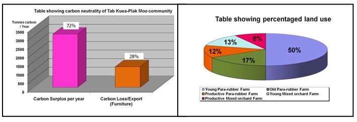
The study reveals that there are 44,601.5 tonnes of carbon produced from each plot of farming land and community forest which accounts for 2,100 Rai in total. Within the 900 Rai of the community forest alone, there is an annual carbon surplus of 72% (3,102.28 tonnes) and a carbon deficit loss from the community through the selling and process of para rubber plants which account for 28% (1,201.76 tonnes) of carbon. Once sold, the lost carbon is then stored in the form of furniture. From these figures, it can be seen that community’s traditional method of agriculture production has a capacity to maintaining cabon surplus than deficit.
With regards to resource management, the community has a clear management plan. For instance, the felling pattern of para rubber trees is based on determining which trees are too old and not producing good quantity of milk. These plants are then replaced with new trees wih care being taken to ensure that no more than 5 plots of old rubber trees are being felled, each plot must has a size that does not exceed 10 Rai. However, these plots must be adjacent to each other in order to preseve the ecosystem. The community also has 11 sacred forest plots which are also managed with strict principles of ecological balance in order to acheive maximum sustainability and abundance. Such management and strategy aims to ensure that there is a good balance of econmmic return, environmental conservation and livelihood security for the whole of the community.
Table shows Findings on Relationship between Global Warming and Ban Tab Kuea – Plak Moo Community’s Producation System
|
Items |
Ban Tab Kuea– Plak Moo Community’s Producation Systems |
|||||
|
Community Forest |
Young Para rubber Farm
|
Productive Para rubber Farm |
Old Para rubber Farm
|
Young Mixed Orchard Farm |
Productive Mixed Orchard Farm |
|
|
900 Rai |
600 Rai |
150 Rai |
200 Rai |
150 Rai |
100 Rai |
|
|
Quanity of carbon storage (tonnes/forest) |
33,930 tonnes (37.7tonnes/Rai) |
648 tonnes (1.08 tones/Rai) |
1,728 tonnes (11.52 tonnes/Rai) |
6,140 tonnes (30.7tonnes/Rai) |
1,273.5 tonnes (8.49 tonnes/Rai) |
882 tonnes (8.82 tonnes/Rai) |
|
%of canopy coverage per Rai |
90.7 % |
- |
82.1% |
89.3 % |
86 % |
89.7 % |
|
% ground coverage per Rai |
94.9 % |
75 % |
100 % |
90 % |
96.6 % |
86.6 % |
|
Soil Infiltration Rate |
1 .9 minutes |
2.95 minutes |
21 seconds |
- |
- |
- |
Unfair Accusations and Penalties Towards Small-Scale Farmers
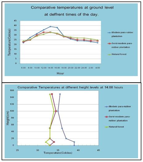
Firstly, temperature - The study tries to compare the temperature and climate of 3 different sites over a 24 hours period. It found that the target community forest site and traditional para rubber plantation share a similar ecoclimate. Interestingly, the targeted newly planted para rubber plantation has the most prominent difference of ecoclimate to that in the community forest site, 21 decree celcius at the ground surface level. The study also found that the higher the altitude, the less differences found between the 3 targeted sites. Therefore, the temperature depends on various factors such as time, altitude, and climate. Therefore, in order to determine a level of increase of temperature we must take into account these factors of the particular sites.
Graphs below show a comparison of the temperatures of 3 Sites at different altitudes over different periods of time.
Soil Minerals and Water Evaporation
The study found that factors that influence soil erosion are the level of top soil coverage and canopy coverage which means the higher level of ground coverage, the lesser the interception of rainfall onto the ground, hence a reduced rate of soil erosion. Based on the comparison between the conditions of the community’s farming land and community forest areas, the study found that a close similarity of top soil and canopy coverage in these two areas, 86.7% to 90.7% and 89.6% to 94.9% especially in mixed orchard farms or the 4 levels farming system where the levels of canopy and top soil coverage are the highest. Meanwhile, a contemporary 1 year old para rubber plantation has no canopy coverage, but has a satisfactory top soil coverage and a denser and richer vegetation coverage other plot. Furthermore, the study found other important undergrowth such as legume crops release nitrogen minerals which are critical for soil fertility. The benefits of the undergrowth are retaining soil moisture and reducing water evaporation from the soil becuase it protects the top soil from direct exposure to sunlight.
Water Infiltration Rate
In general, the soil condition in the community forest area is enriched by minerals released from decomposed plants and animals remains and sedimentation that has been accumulated for a long time. Because of high fertility, water and moisture infiltration rate is higher than anywhere else. The recent studies revealed that the traditional pararubber plantation has the fastest rate of water infiltration. Moreover, it was also found that newly planted pararubber trees densely located at a low level have a higher water infiltration rate than in the community forest area.
The findings of the research show that prosecuting local farmers for increasing global warming has no valid ground and clearly has no justice and contradict the reality found in the local area. The study also highlights the community’s traditional agricultural wisdom where ecological balance is acheived so that natural resources are not exploited but being conserved to benefit the local communities and society as a whole.

มูลนิธิชีวิตไท (Local Act)
129/250 หมู่บ้านเพอร์เฟคเพลส รัตนาธิเบศร์ ถนนไทรม้า ต.บางรักน้อย อ.เมือง จ.นนทบุรี 11000
โทรศัพท์: 02 040 9969 | 090 178 7508
E-mail : This email address is being protected from spambots. You need JavaScript enabled to view it.


